There is a particular silence that settles over ancient Asian ruins. It is not empty—it hums. Wind threading through stone corridors, tree roots tightening their slow grip, incense drifting from shrines that refuse to become relics. These are not dead places. They are negotiations between past and present, and if you move carefully, they will let you in.
This field guide is not a checklist. It’s a way of seeing.
Ruins are often misread as endings. In Asia, they’re usually evidence of transition—civilisations bending, fragmenting, relocating, or dissolving into something less visible. What remains in stone is only the loudest part of the story. Let’s go deeper.
Angkor, Cambodia — The Empire That Refused to Vanish
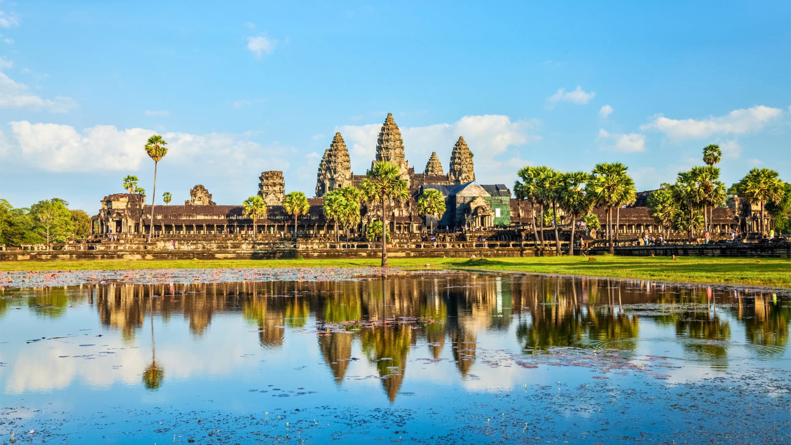
At dawn, the moat of Angkor Wat holds a near-perfect reflection. Tourists gather, phones raised, waiting for the sun to crest. But step slightly away from the crowd and the real moment reveals itself—the low chant of monks somewhere beyond sight, the smell of damp earth, the sudden awareness that this place was never meant to be seen all at once.
What are the focal points at Angkor?
- Angkor Wat
- Banteay Kdei
- Prasat Ta Som
- Terrace of the elephants
- Ta Prohm
- Banteay Srei Temple
- Bayon Temple
- Neak Pean Temple
- Angkor Thom
- Angkor travel tips
Angkor is not a single temple. It’s a sprawl of ambition. The Khmer Empire built in stone what it believed was cosmic order—temples aligned to stars, corridors designed as metaphors for eternity.
But the most compelling site is arguably Angkor Wat or Ta Prohm, where silk-cotton trees collapse the distinction between architecture and wilderness. Roots pour over walls like molten rock. You don’t walk through Ta Prohm so much as you are absorbed by it.
What is important about Angkor Wat?
Angkor Wat was designed as a miniature physical representation of the Hindu universe. Constructed by King Suryavarman II in the 12th century, its architecture combines profound spiritual symbolism with immense scale. Built by the Khmer King Suryavarman II it served as his state temple and eventual royal mausoleum.
- The Spiritual Axis: The Bakan is Angkor Wat’s highest terrace and sacred center. Historically, only the king and high priests were allowed to climb its steep stairs.
- The Five Lotus Towers: Five lotus-bud towers form a quincunx above the central temple. The tallest, at the center, rises about 65 meters (213 feet) above the ground. Together, the towers represent the sacred peaks of Mount Meru, the mythical home of the gods and the center of the universe in Hindu and Buddhist cosmology.
- The Cosmic Ocean: The complex is surrounded by a massive moat that is 200 meters wide (620 feet) and more than 3 miles long. Symbolically, it represents the cosmic ocean at the edge of the world.
- Engineering expertize: Beyond the cosmic ocean’s symbolic meaning, modern engineers have found that the moat also serves a practical purpose: it regulates groundwater pressure and helps stabilize the immense sandstone structure on Cambodia’s shifting soil.
- The Western Alignment: Unlike almost all other Khmer temples, which face east toward the rising sun, Angkor Wat faces west. This direction is traditionally associated with Vishnu, the temple’s patron deity, and with funerary rituals.
- Equinox Phenomenon: The alignment of Angkor Wat also creates a remarkable solar alignment: twice a year, during the spring and autumn equinoxes, the sun rises directly over the tip of the central lotus tower.

What to see in the Temple of Banteay Kdei
- Banteay Kdei: The name translates to “A Citadel of Chambers” or “Citadel of Monks’ cells
- The Hall of Dancers: Located just inside the eastern entry, this pillared hall features delicate bas-relief carvings of apsara dancers.
- Gopuras (Face Towers): The eastern and western entrance gateways feature serene carved four-faced towers reminiscent of the Bayon and Angkor Thom.
- Devata Carvings: Well-preserved stone carvings of devatas (deities) adorn the upper sections of the interior walls and towers.
- Intricate Labyrinths: A quiet, less-crowded maze of interconnected halls and collapsing chambers that offer an intimate look at ancient monastic life.
- Srah Srang: Located directly across the road from the eastern gate, this massive royal bathing reservoir is famous for its open waters and brilliant sunrise views.

What You Need To Know About The Terrace Of Elephants
The Terrace of the Elephants is among the most impressive monuments within Cambodia’s ancient walled city of Angkor Thom. Extending north to south along the eastern side of the Royal Palace grounds, this vast stone platform served as the public front of the Khmer Empire’s royal court.
- The Elephant Parade: As its name suggests, the outer walls at either end of the terrace feature continuous, life-sized bas-reliefs depicting a procession of elephants. Led by their mahouts (handlers), the elephants are shown marching, hunting in the jungle, and battling wild tigers.
- Airavata Three-Headed Elephant Pillars: Freestanding stone columns guarding the secondary stairwells depict Airavata, the mythical multi-headed elephant ridden by Indra. Their descending trunks serve as columns and are carved pulling lotus bouquets from the ground.
- The Central Grandstand: Directly before the Royal Palace entrance, this section features a grand cruciform staircase and raised lotus-throne rostrum for the king. Its retaining walls are supported by carved Garudas and standing lions, appearing to hoist the terrace.
- The Five-Headed Horse: Near the terrace’s northern end, this hidden relief depicts a sacred five-headed horse surrounded by dancers and fleeing warriors.
- Parasol Postholes: Along the terrace’s flat stone surface are original hollow postholes, used to secure poles for large silk parasols shading the royal court.

What are the key features at Prasat Ta Som?
Prasat Ta Som was built at the end of the 12th century (circa late 1100s to early 1200s) during the reign of King Jayavarman VII, the prolific Mahayana Buddhist ruler responsible for the Bayon and Angkor Thom
- Famous Eastern Gopura (Tree Gate): Ta Som’s highlight is its eastern gateway tower, dramatically enveloped by the roots of a giant strangler fig. It offers a picturesque “nature reclaiming architecture” scene reminiscent of Ta Prohm, but on a quieter scale.
- Bayon-Style Face Towers: The entrance gopuras feature serene four-faced towers depicting Avalokiteshvara, the bodhisattva of compassion.
- Devata and Apsara Carvings: The single-level walls feature delicate bas-reliefs of standing female deities and dancing heavenly spirits.
- Compact Layout: Enclosed by laterite walls and a moat crossed by a naga-lined pathway, the temple can be explored in 30–45 minutes.

What are the points of interest at Ta Prohm?
Ta Prohm is a famous 12th-century jungle temple renowned for its dramatic colossal tree roots growing directly over ancient stone ruins.
- The Giant Trees: Towering silk-cotton trees (Tetrameles nudiflora) and strangler figs (Ficus gibbosa) grow through the stone corridors, with thick roots breaking through roofs and gripping the courtyard walls.
- The “Tomb Raider” Location: The temple gained modern pop-culture fame after serving as a main filming location for the 2001 movie Lara Croft: Tomb Raider.
- The Hall of Dancers: A carefully restored laterite-plinth structure that showcases traditional Khmer architectural design.
- The “Dinosaur” Carving: A curious bas-relief on one of the outer walls depicts a four-legged creature with circular plates along its back, which some visitors and researchers compare to a Stegosaurus.

Field Notes:
- Arrive before 6am or after 3pm to avoid the tour buses.
- Hire a local guide—not for facts, but for stories. They’ll point out details you’d otherwise miss.
- Move slowly. Angkor rewards patience.
The Khmer Empire didn’t just build temples—it engineered a landscape. At its height (9th–15th century), Angkor may have been the largest pre-industrial city on Earth, home to nearly a million people.
The empires power came from water. A vast network of canals, reservoirs (barays), and embankments turned monsoon chaos into agricultural certainty. Angkor Wat itself is aligned with cosmic symbolism, but it also sits within this engineered ecosystem—religion and infrastructure fused.
“The Khmer Empire didn’t just build temples—it engineered a landscape. At its height (9th–15th century), Angkor may have been the largest pre-industrial city on Earth, home to nearly a million people.“
– Destinations Uncovered


What are the focal points of Banteay Srei temple?
Often described as Angkor’s “precious gem,” Banteay Srei boasts decorative reliefs and pediments with an intricate level of detail unmatched by its larger counterparts. The modern Khmer name translates to “Citadel of Women”, inspired by the delicate, graceful carvings of devatas and minor female deities, which historically led locals to believe only women could have carved them.
- The Inner Enclosure: This central area contains the complex’s main architectural and artistic highlights.
- The Two Libraries: Located on either side of the central path within the innermost courtyard, these buildings feature the site’s deepest and most detailed relief carvings.
- The Central Sanctuary: Primarily dedicated to the Hindu god Shiva, the main shrines contain exquisite devatas (goddesses) and lintel carvings depicting mythological stories.
- Intricate Tympanums and Pediments: The triangular gables above the doorways portray well-known scenes from Hindu epics, including stories about Shiva and Vishnu.
- The Pink Sandstone Material: The stone’s distinctive reddish-pink color changes with the natural light, glowing especially brightly at sunrise and sunset.
What happened at Angkor Wat?
The decline wasn’t a single collapse but a slow unravelling. Recent research suggests a combination of:
- Severe climate swings (decades-long droughts followed by intense floods)
- Damage to the water management system
- Political pressure from neighbouring kingdoms like Ayutthaya
- You can customize lists now to look any way you like
By the 15th century, the elite had shifted south toward Phnom Penh. Angkor was never fully abandoned—monks continued to use temples—but its urban system failed.


What is the significance of Bayon temple?
The Bayon temple, situated at the precise geographic center of Cambodia’s ancient royal city of Angkor Thom, is renowned worldwide for its mysterious, multi-layered design. Constructed in the late 12th or early 13th century during the reign of King Jayavarman VII, it represents Mount Meru on Earth—the center of the universe in Buddhist and Hindu cosmology.
- The Serene Smiles: Around 37 of the original 54 face towers remain, adorned with over 200 colossal, gently smiling faces. Each is about 4 meters tall and faces a cardinal direction.
- The Identity Debate: Historians debate whether the faces depict Avalokiteshvara, the Hindu god Brahma, or a deified likeness of King Jayavarman VII watching over his empire.
- The Outer Gallery: Depicts historical events and everyday Khmer life, including a massive naval battle on Tonle Sap between Khmer and Cham forces. It also offers rare glimpses of 13th-century activities such as cooking, cockfighting, market shopping, and fortune-telling.
- The Inner Gallery: Located on the second level, focuses on mythology, featuring Hindu legends, Buddhist folklore, and grand royal processions with the king and apsara dancers.
Little-known Angkor details:
- The famous faces of Bayon Temple may represent the king Jayavarman VII as a bodhisattva—a blend of ruler and deity.
- Ta Prohm is intentionally left semi-restored—not as neglect, but as a curated glimpse of how Europeans first encountered Angkor in the 19th century.
- The “abandonment” narrative is misleading. Angkor was never truly abandoned; it simply changed scale and significance.

What are the key features of Neak Pean temple?
Neak Pean is a 12th-century artificial island temple built during the reign of King Jayavarman VII
- Central Island and Lotus Base: The shrine rises from a double lotus-petal base, making the island appear to float.
- Entwined Serpents: Two large Naga statues, called Neak Pean, coil around the island’s base.
- Flying Horse: A stone statue of Balaha, a form of the compassionate bodhisattva Lokesvara, stands on the east side with figures clinging to it to escape drowning.
- Central Shrine: This cruciform sanctuary, dedicated to Avalokiteshvara, has an eastern entrance and carved false doors on the other three sides.
- Four Peripheral Pools: Four smaller pools connect to the central pool and symbolize water, fire, earth, and wind in Hindu and Buddhist cosmology.
- Animal Waterspouts: Fountainheads shaped like an elephant, lion, horse, and human represent water, fire, air, and earth.
- Healing Purpose: Built by King Jayavarman VII in the 12th century, the complex served as a medical bathhouse where people bathed to balance their bodily elements and cure ailments.

What is the significance of the gates and causeways of Angkor Thom?
Angkor Thom, the final and longest-lasting capital of the Khmer Empire, is a vast fortified citadel covering 9 square kilometers. Founded in the late 12th century by King Jayavarman VII, the city is a remarkable example of Buddhist cosmology and urban planning. The main highlights of Angkor Thom include its iconic gateways, magnificent state temples, and royal terraces:
- The Five Monumental Gates and Causeways: The entire city is surrounded by an 8-meter-high defensive wall and a massive 100-meter-wide moat. Entry is possible through one of five heavily fortified gates, known as gopuras.
- The South Gate: This is the most famous and best-preserved entrance and serves as the main entry point for visitors.
- The Naga Causeways: Each gate is reached by a stone bridge lined with 108 large stone figures—54 gods (devas) on one side and 54 demons (asuras) on the other—depicting the Hindu myth of the Churning of the Ocean of Milk.
- The Face Towers: Each monumental gate is topped with four giant, enigmatic stone faces, each looking toward one of the cardinal directions.
Top Angkor travel tips:
- Dress Appropriately: Cover shoulders and knees. As a, religious site, strict dress codes are enforced
- Beat the Heat & Crowds: Start your day at 5:00 AM for the famous sunrise, then explore before the midday heat (35°C–40°C in April).
- Hydration is Key: Bring plenty of water and wear comfortable shoes; you will be walking a lot, say Responsible Travel and Travel Talk Tours.
- Sunrise at the Equinox: Visit around 20 March or 23 September to see the sun rise directly over the central summit
The best time to visit Angkor is during the cool, dry season from November to February, offering pleasant temperatures
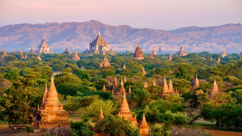
Bagan, Myanmar — The Plain of a Thousand Temples
The first thing you notice in Bagan is scale. Thousands of temples rise from the dry earth, scattered like fragments of a forgotten constellation.
At sunrise, hot air balloons drift across the horizon—not as spectacle, but as punctuation. The real drama is on the ground. Inside temples like Ananda Temple, light cuts through narrow windows and lands on Buddha statues with surgical precision. It feels intentional, even if you don’t understand the geometry behind it.
Bagan is quieter than Angkor, less curated. Many temples are still crumbling, their interiors half-claimed by dust and shadow. It gives you space to imagine.
Field Notes:
- E-bikes are the best way to explore—silent, slow, and forgiving.
- Climbing temples is now restricted in many areas; respect the rules.
- Dust is part of the experience. Bring a scarf.
What is the significance of the Bagan area in Myanmar?
Bagan is a UNESCO World Heritage Site and one of the world’s greatest archaeological landscapes. As the ancient capital of the Pagan Kingdom, it played a crucial role in unifying the regions of modern Myanmar. Between the 11th and 13th centuries, its kings and citizens built more than 10,000 Buddhist monuments across the vast plain. Today, over 2,200 temples and pagodas remain, standing as a powerful testament to early Buddhist devotion, distinctive architecture, and exceptional Burmese craftsmanship.
- Cradle of Myanmar Culture: Bagan, capital of the first unified Burmese empire, united diverse peoples and shaped modern Burmese language, script, and culture.
- Spiritual Heart of Theravada Buddhism: The empire helped establish and spread Theravada Buddhism across Southeast Asia. Its temples and stupas were built to earn spiritual merit.
- Architectural and Artistic Peak: Bagan showcases the evolution from solid relic stupas to hollow gu-style temples for worship and meditation, featuring ancient stucco, stone carvings, and vibrant frescoes.
Religion here wasn’t passive; it was transactional. Constructing a temple was a way to accumulate spiritual merit for the next life.


What happened to the civilisation at Bagan?
Bagan’s fall is often attributed to the Mongol invasions of Burma under Kublai Khan. While invasions destabilised the kingdom, the deeper issue was internal:
- Political fragmentation followed
- Massive land donations to religious institutions weakened the state’s economic base
- Bagan never recovered its centralised power, though it remained a religious hub.
Little-known Bagan details:
- Ananda Temple is considered the architectural “perfect temple,” blending Mon and Indian influences.
- Earthquakes (not time alone) are responsible for much of Bagan’s damage—the 1975 quake was particularly devastating.


What are the key features and important sites at Bagan?
- Ananda Temple: Often known as the “Westminster Abbey of the East,” it is a stunningly symmetrical masterpiece of Mon-style architecture. Inside are four towering Buddha statues covered in gold leaf, whose expressions seem to change as you move around them.
- Shwezigon Pagoda: Located in Nyaung-U, this enormous, gold-leaf-covered circular pagoda became the model for classic Burmese-style stupas. It is highly sacred and believed to house a bone and tooth relic of Gautama Buddha.
- Dhammayangyi Temple: The largest and most massive structure on the plains, it was built by the tyrant King Narathu and is renowned for its impressive brickwork, fitted so precisely that not even a needle can pass between the bricks.
- Thatbyinnyu Temple: Rising more than 60 metres, this towering white temple is Bagan’s tallest monument, dominating the Central Plains skyline.
- Sunrise or sunset from viewing mounds: Watch the sun rise over misty plains as ancient spires cast long shadows. Since temple climbing is restricted, enjoy the view from government-approved earthen mounds.
- Hot-air balloon rides: Fly over the archaeological zone at sunrise for a panoramic view of the temples.
- Lacquerware workshops in Myinkaba: Visit traditional workshops to see artisans create hand-carved lacquerware using centuries-old techniques.
- Nyaung-U Local Market: Experience local life, sample traditional snacks, and browse regional spices and textiles.
Sukhothai – The Dawn of Happiness

Sukhothai, a UNESCO World Heritage Site, holds great historical importance as Thailand’s first independent kingdom, known then as Siam, which flourished from the 13th to the 14th centuries. Often referred to as the “Dawn of Happiness,” Sukhothai marked the golden age of Thai culture, giving rise to distinctive art styles, the Thai alphabet, and traditional Theravada Buddhist practices. Today, its well-preserved ruins lie within a peaceful, park-like setting, providing a striking contrast to Southeast Asia’s busier archaeological sites.
What is the historical significance of Sukhothai?
Cradle of Thai Nationhood: Founded in 1238, Sukhothai liberated itself from Khmer rule, marking the birth of a distinct, unified Thai identity. Its most famous monarch, King Ramkhamhaeng, is credited with creating the Thai alphabet.
The “Sukhothai Style” of Art: This era introduced a distinct architectural and artistic style. It is best known for the elegant, fluid, and serene “Walking Buddha” statues, which broke away from rigid Khmer artistic conventions.
Mastery of Hydraulic Engineering: The city was built with an advanced network of reservoirs, moats, and ponds. This sophisticated water-management system allowed the capital to thrive agriculturally and structurally.
What are the most important sights at Sukhothai?
The ruins are divided into five distinct zones, with the Central Zone and Northern Zone hosting the most iconic monuments.
The Central Zone (Inside the Ancient City Walls)
- Wat Mahathat: The spiritual and administrative center of the ancient empire. This vast complex is dominated by a central lotus-bud-shaped stupa, a defining feature of Sukhothai architecture, surrounded by numerous smaller stupas, rows of pillars, and two towering standing Buddha images (Phra Attharot).
- Wat Si Sawai: Situated just south of Wat Mahathat, this temple is known for its three striking, elaborately decorated prangs (towers). The Khmers first built it as a Hindu shrine, and it was later transformed into a Buddhist temple under the Sukhothai kingdom.
- Wat Sa Si: Beautifully situated on an island in the center of a large lotus pond, this temple is reached by a wooden footbridge. It features a classic Sinhalese-style stupa and an exceptionally graceful bronze statue of a walking Buddha.


The Northern Zone
- Wat Si Chum: Home to one of Thailand’s most iconic and striking sights: Phra Achana, a colossal 15-metre-tall seated Buddha visible through a narrow vertical opening in the surrounding roofless brick enclosure, known as a mondop. The Buddha’s serene expression and gold-leaf-covered fingers are famous around the world.

Other Essential Features and Experiences
- Wat Saphan Hin (The Western Hill Zone): Set on a forested hill outside the city walls, this tranquil temple is reached by a slate pathway. Its main feature is a 12-metre-tall standing Buddha overlooking the Sukhothai plains. Watching the sunrise from this viewpoint is highly recommended.
- The Ramkhamhaeng National Museum: Located near the central park entrance, this museum offers valuable historical context. It displays original bronze Buddhas, ancient stone inscriptions—including copies of the famous King Ramkhamhaeng stele—and artifacts that reveal the city’s development.
- Sangkhalok Ceramic Kilns: Sukhothai was once a major Asian exporter of glazed pottery known as Sangkhalok ware. Visitors can explore ancient kiln ruins in the Northern Zone or visit workshops in the modern town to paint their own traditional fish-patterned plates.
- Sukhothai Saturday Night Market: If you are visiting on a weekend, be sure to explore the lively night market beside the Historical Park’s illuminated lakes. It is a wonderful place to try local specialties such as Kuay Tiew Sukhothai, a local rice noodle dish served with sweet and savory pork broth, ground peanuts, and green beans.
- Loy Krathong: If visiting around November check if you are there for the Loy Krathong Festival which falls on the full moon of the 12th month in the traditional Thai lunar calendar. Loy Krathong is a popular Thai festival of lights where people float small, decorated baskets on rivers and lakes to honor the water goddess and let go of negativity
Top Tips for Visiting Sukhothai

To make the most of your trip to Sukhothai, a bit of strategic planning goes a long way. Because the ruins are highly organized but spread out across five distinct zones, handling transport and timing correctly will completely transform your experience.Here are the top insider tips for visiting Sukhothai Historical Park:
- Ditch Walking, Rent a Bicycle or E-Scooter: The park is far too sprawling to explore entirely on foot, especially in the tropical heat. Right outside the main entrance to the Central Zone, you can find bicycle rental shops charging around 30 to 50 THB (approx. $1.50–$2.50 NZD) for the day.
- Time Your Visit for ‘Golden Hours‘: The mid-day heat in Sukhothai can be intense, and the flat landscape offers very little shade.
- Morning: Aim to enter the park right when it opens at 6:30 AM. Head straight to Wat Saphan Hin in the Western Zone to watch the sunrise over the misty plains, or enjoy the Central Zone completely crowd-free.
- Evening: Return around 4:30 PM when the sun goes down. The temples cast beautiful long shadows, the stone turns a rich orange hue, and the temperature drops comfortably.
- See the Temples Lit Up at Night: Do not leave as soon as the sun sets! On Friday, Saturday, and Sunday evenings, the central ruins (including Wat Mahathat and Wat Sa Si) are beautifully illuminated by spotlights. Wandering or cycling past the glowing ancient structures against the dark night sky is arguably the most magical experience in Sukhothai.
- Split Your Tickets (or Prioritise Zones): The historical park charges separate admission fees for different zones (100 THB per zone, plus a small fee for your bicycle). If you are short on time or budget, prioritize these two:
- The Central Zone: Contains the highest concentration of spectacular ruins, walls, and lotus ponds.
- The Northern Zone: Costs a separate fee but is completely worth it just to see the colossal hidden Buddha at Wat Si Chum.
- Stay in ‘Old Sukhothai’: Sukhothai is divided into two distinct areas located about 12 kilometres apart, New Sukhothai (a bustling modern residential town) and Old Sukhothai (the quiet village right next to the historical park). For the best experience, book your accommodation in Old Sukhothai. This allows you to easily cycle into the park at dawn, retreat to your hotel pool or a café during the scorching mid-day heat, and wander back out for sunset without dealing with songthaew (local truck-bus) commutes.
- Try the Local Noodles: While you are there, you must order a bowl of Kuay Tiew Sukhothai (Sukhothai Noodles). It is a distinct, highly celebrated regional variant of Thai rice noodles served with sliced pork, minced pork, crispy pork cracklings, long green beans, crushed peanuts, and a squeeze of lime in a slightly sweet, savory broth.

What happened to the kingdom of Sukhothai?
Sukhothai was abandoned gradually rather than destroyed by a single disaster. After King Ramkhamhaeng’s death in 1298, the kingdom weakened, while Ayutthaya—founded in 1350—grew stronger through trade and military expansion. Sukhothai became an Ayutthaya vassal in 1378 and was formally annexed in 1438, losing its political importance.
The city remained inhabited for some time, but in 1583 King Naresuan ordered its population to relocate south during the Burmese–Siamese Wars, partly to prevent invading forces from using Sukhothai’s resources. Without its people, homes and wooden buildings decayed, while the temples were gradually covered by vegetation. Archaeological restoration later transformed the ruins into the Sukhothai Historical Park.
The abandonment of Sukhothai was not caused by a single catastrophic explosion or sudden disaster, but rather by a gradual shift in political power, warfare, and a forced relocation of its population. And so Sukhothai transitioned from thriving capital to a ghost city swallowed by the jungle.
Hampi, India — The City That Was Too Visible
Hampi is an extraordinary UNESCO World Heritage Site in Karnataka, India. It was the magnificent 14th-century capital of the Vijayanagara Empire and, at its height, one of the world’s wealthiest and largest cities. Grand palaces, impressive temples, and bustling international markets defined the city before it was sacked and abandoned in 1565. Today, its remarkable ruins stretch across a dramatic landscape of enormous granite boulders, lush banana plantations, and the Tungabhadra River.
Hampi feels less like a ruin and more like a landscape interrupted.
Massive granite boulders balance improbably across the terrain, as though placed by a distracted giant. Between them, the remains of the Vijayanagara Empire stretch out—temples, markets, aqueducts.
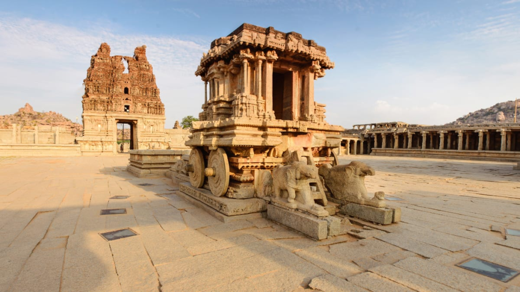
At Vittala Temple, the stone chariot sits immobile yet somehow kinetic, its carved wheels suggesting motion. Nearby, pillars that once produced musical notes stand silent, protected from curious hands.
- Make sure to cross the river to explore the quieter side of Hampi.
- See the sunrise from Matanga Hill, it reframes the entire landscape.
- Stay longer than planned—Hampi resists quick visits.
What makes Hampi different is that life continues among the ruins. Laundry dries on temple steps. Children play cricket in ancient courtyards.
Field Notes:
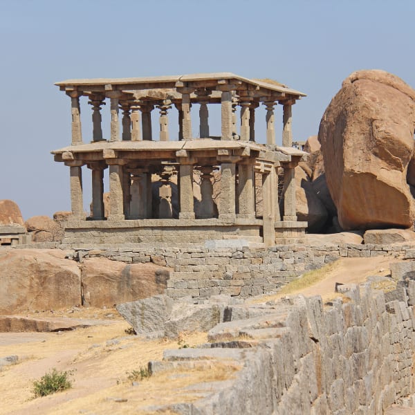
What are the most important sites at Hampi?
- Virupaksha Temple, Hampi: As Hampi’s only continuously functioning temple since the 7th century, it is distinguished by its impressive 49-metre-high gateway, known as a gopuram. Don’t miss Lakshmi, the temple’s resident elephant, and step inside to see a remarkable inverted image created by a natural pinhole camera effect in the architecture.
- Vitthala Temple Complex: This is Hampi’s greatest artistic masterpiece. It features the iconic Stone Chariot, depicted on India’s ₹50 banknote. The complex is also renowned for its विशाल Ranga Mantapa pavilion, whose 56 “musical pillars” produce distinct musical notes when gently tapped.
- Hemakuta Hill: Situated beside Virupaksha Temple, this sloping granite hill is dotted with pre-Vijayanagara temples resembling miniature pyramids. It offers the best and most easily accessible viewpoint for watching the sunset over the boulder-strewn landscape.
- Lotus Mahal: A beautiful two-story pavilion within the Zenana Enclosure, the private quarters for royal women. It is renowned for its distinctive, highly photogenic Indo-Islamic architecture, shaped like a half-opened lotus bud.
- Elephant Stables: Positioned right behind the Lotus Mahal, this grand, symmetrical structure features 11 domed chambers that once housed the empire’s elite royal fighting elephants.
- Mahanavami Dibba: A massive, three-level stone platform adorned with intricate carvings of elephants, horses, dancers, and foreign merchants. The emperors stood on top of it to observe military parades and lavish festivals.
- The Queen’s Bath: A large, simple square building from the outside that opens into a stunning, ornate sunken indoor pool surrounded by Rajasthani-style arched balconies.
- Ugra Narasimha (Lakshmi Narasimha): A fierce, 6.7-metre monolithic statue of Lord Vishnu as a half-man, half-lion, seated beneath the many-headed serpent Adishesha.
- Badavilinga: Beside Narasimha, this 3-metre stone Shiva Linga remains submerged in water from an ancient canal system.
- Sasivekalu and Kadalekalu Ganesha: Two huge monolithic statues of Ganesha, carved from single boulders on Hemakuta Hill.

At its height in the 14th–16th centuries, Hampi was one of the richest cities in the world. Foreign travellers compared it to Rome. The Vijayanagara Empire built not just temples but entire urban systems—markets stretching for kilometres, royal enclosures, irrigation networks.
What happened at the ancient Asian ruins of Hampi?
The fall was sudden and violent. In 1565, the empire was defeated at the Battle of Talikota by a coalition of Deccan sultanates. What followed:
- The city was looted and systematically destroyed
- Structures were burned, toppled, or abandoned
- Unlike Angkor, Hampi’s decline was immediate and catastrophic.

Things to see ane experience at Hampi:
- Coracle Ride on the Tungabhadra River: Board a traditional, round wicker boat known as a coracle to discover hidden riverside carvings and feel the river’s currents.
- Climb Matanga Hill: Adventurous travelers can take a steep morning trek up the rocky steps of Matanga Hill for an unforgettable 360-degree sunrise view across the ancient empire.
- Incredible symbolim: In these ancient asian ruins you’ll find the incredible Stone Chariot. Situated at Vittala Temple this chariot never moved—it’s symbolic, not functional.
- Architectural brilliance: The famous “musical pillars” were damaged by colonial-era attempts to extract their sound.
- Life within Hampi: Virupaksha Temple has remained continuously active—worship never stopped, even after the city fell.
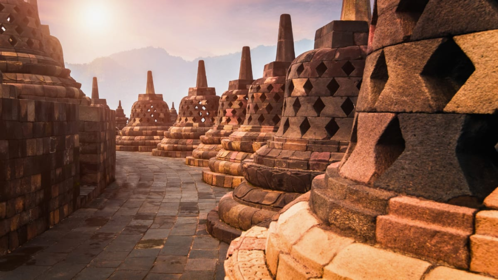
Borobudur, Indonesia — A Monument to Enlightenment
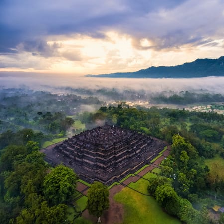
There is a rhythm to Borobudur. You ascend it, level by level, like reading a text written in stone.
Each terrace at Borobudur tells a story—reliefs depicting the journey toward enlightenment. By the time you reach the top, the world opens up. Volcanoes line the horizon. The air thins. The noise drops away.
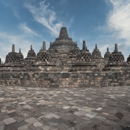
The Borobudur stupas, the bell-shaped structures housing Buddha statues, are both repetitive and hypnotic. You begin to understand that repetition is the point.
Borobudur is less about spectacle and more about process. It asks you to slow down, to notice patterns, to participate.
Field Notes:
- Sunrise access requires a special ticket but is worth it.
- Walk the full circuit rather than heading straight to the top.
- Respect the spiritual nature of the site—this is still a place of pilgrimage.
Built in the 8th–9th centuries by the Sailendra Dynasty, Borobudur is less a building and more a three-dimensional mandala.
Pilgrims would walk its levels clockwise, reading the reliefs like scripture—ascending physically and spiritually.
What happened to the civilisation at Borobudur?
Borobudur’s decline is tied to broader shifts:
- The rise of Islam across Java
- Political centres moving شرق (eastward)
- Volcanic eruptions covering the site in ash
By the 14th century, it was largely abandoned and eventually reclaimed by jungle.
It was “rediscovered” in 1814 by Thomas Stamford Raffles during British rule.
Little-known Borobudur details:
- The structure has no interior chambers—it’s meant to be experienced externally, through movement.
- Hidden base reliefs (covered during construction) depict karma in stark, sometimes brutal detail.
- The restoration in the 20th century involved dismantling and rebuilding large sections stone by stone.
How to really experience these Ancient Asian Ruins
Ancient ruins are often framed as things to “see.” That’s the wrong instinct. Instead:
- Listen first. What sounds exist here that wouldn’t elsewhere?
- Notice absence. What’s missing tells you as much as what remains.
- Follow the edges not jut the paths. Find the overlooked corners that hold the most intact stories.
- Stay longer than planned. Rest in the ruins and let them reveal themselves to you
Asia’s ancient sites are not static attractions. They are ongoing partnerships—between nature and architecture, memory and forgetting, you and something much older.
Final Notes: Civilisations Don’t End—Ancient Asian Ruins
The instinct is to ask: why did these civilisations collapse? A better question: where did they go?
- The Khmer didn’t vanish—they shifted their capital and adapted.
- Bagan’s culture persists in Myanmar’s religious life.
- The Nabataeans were absorbed into larger empires.
- Vijayanagara’s legacy survives in South Indian culture and architecture.
- Borobudur’s builders faded, but their ideas travelled through religion.
Ruins are not evidence of failure. They are what happens when power, environment, belief, and time fall out of alignment. Stand in any of these places long enough, and the narrative changes. You stop seeing endings. You start seeing the tapestry of time and history.
After your day in ancient ruins you will want to head to local beaches. If you haven’t yet, you need to check out our guide to Asia’s best beaches. And while there make sure to bookmark our guide to the best Caribbean Islands.
14 Works Cited
Aung, Tharaphy, and Arun Menon. “Leveraging Digital Systems for Disaster Management at the UNESCO World Heritage Site of Bagan Archaeological Zone in Myanmar.” Managing Disaster Risks to Cultural Heritage, 2023, pp. 258-269, https://doi.org/10.4324/9781003263647-16.
britannica.com. Pagan kingdom. 2026, www.britannica.com/place/Pagan-kingdom.
Contributors to Wikimedia projects. archaeological site and Hindu empire in Cambodia. Wikimedia Foundation, Inc., 2004, en.wikipedia.org/wiki/Angkor_Thom.
—. 1565 battle between the Deccan Sultanates and Vijayanagara Empire. Wikimedia Foundation, Inc., 2005, en.wikipedia.org/wiki/Battle_of_Talikota.
—. series of military conflicts between Burma and Siam. Wikimedia Foundation, Inc., 2011, en.wikipedia.org/wiki/Burmese%E2%80%93Siamese_wars.
—. 1277 historical conquest. Wikimedia Foundation, Inc., 2014, en.wikipedia.org/wiki/First_Mongol_invasion_of_Burma.
Diskul, M. C. Subhadradis, and Caroline Baicy. “Sukhothai.” Oxford Art Online, 2003, https://doi.org/10.1093/gao/9781884446054.article.t082267.
ebsco.com. Rise of the Sailendra Family | History | Research Starters | EBSCOhost. EBSCO, www.ebsco.com/research-starters/history/rise-sailendra-family.
Esichaikul, Ranee, and Rochaporn Chansawang. “Community participation in heritage tourism management of Sukhothai historical park.” International Journal of Tourism Cities, vol. 8, no. 4, 2022, pp. 897-911, https://doi.org/10.1108/ijtc-03-2021-0035.
heritage-line.com. Heritage Line Magazine I King Jayavarman VII – Hero of the Khmer Empire & Angkor. Heritage Line, 2025, heritage-line.com/magazine/story-of-king-jayavarman/.
A journey through the sacred sites of Hampi. Incredible India, www.incredibleindia.gov.in/en/karnataka/hampi/a-journey-through-the-sacred-sites-of-hampi.
Roy Cavanagh. King Ramkhamhaeng the Great. Thaizer, 2012, www.thaizer.com/king-ramkhamhaeng-the-great/.
UNESCO World Heritage Centre. Borobudur Temple Compounds. whc.unesco.org/en/list/592/.
vijayanagara.nic.in. History of Vijayanagara | Vijayanagara District Website | India. 2025, vijayanagara.nic.in/en/about-district/.